
The sun’s boundary lines
Do you know why most globes are tilted on their stands? It’s because the
earth is tilted. Because of this tilt, different places on earth get
different amounts of sunlight. Special lines on globes and maps mark the
edges of these different places.
Halfway between the North and South poles is the imaginary line we call
the equator. At the equator, it is always daylight for twelve hours each
day. So days and nights are the same length all year long.
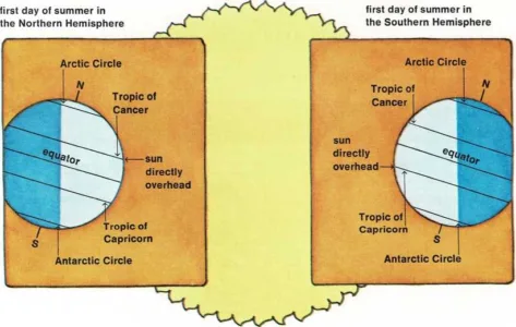
North of the equator is an imaginary line called the Tropic of Cancer.
South of the equator is another line called the Tropic of Capricorn.
Both lines are named for star constellations. Once a year the sun is
directly over the Tropic of Cancer. That’s the first day of

It’s a Fact
At the North Pole, the sur never sets from about March 20 to about
September 23.
summer in the Northern Hemisphere. Once a year, the sun is directly over
the Tropic of Capricorn. That’s the first day of summer in the Southern
Hemisphere.
Near the North and South poles are two other imaginary lines—the
Arctic Circle and the Antarctic Circle. In the region between the Tropic
of Cancer and the Arctic Circle, the sun always shines down at a slant.
The same thing is true in the region between the Antarctic Circle and
the Tropic of Capricorn. So in these regions, days are long during part
of the year and short during another part of the year.
North of the Arctic Circle is a region sometimes called the “Land of the
Midnight Sun.” In the summer, there are days when the sun never sets.
You can go out at midnight and see the sun! But in the winter, there are
days when the sun never rises. The same thing is true south of the
Antarctic Circle.